Category: Travel

  • T-Mobile Simple Choice Plan

    I switched to AT&T when the first iPhone was released and have had no coverage issues for the most part. Of course, if I ventured to the Grand Canyon or another remote part of the United States, all bets were off, but that is to be expected.

    The one thing I did not like about AT&T was whenever I had to travel overseas. Basically, I had to turn off cellular, forward my number to Google Voice, and rely on hotel wi-fi. Being disconnected from electronic devices can be liberating, but sometimes having a phone in hand is essential. Recently, I had a chance to test the T-Mobile Simple Choice Plan when traveling to Peru.

    The plan is supposed to charge $0.20/min for voice, and provide free and unlimited data and text. However, calls to Peru from the United States cost $2.69/min (I later discovered).

    In terms of data and text, I accrued no extra charges. T-Mobile reported that I had used 263MB of data. AT&T charges $30 for 120MB of data with an overage charge of $0.25/MB, and $60 for 300 MB of data with an overage charge of $0.20/MB. On AT&T, it would have cost me $30.00 + $35.75 under their Passport plan or $60 under the Passport Plus. Although the iPhone was displaying the 3G icon, the data speeds were not 3G. It felt more like EDGE with the slow loading maps.

    In terms of voice, the big surprise was the $5.38 charge for a two-minute call to Peru. That was unexpected. However, I had a number of short calls to 800 numbers that were not charged because they were over hotel Wi-Fi. The only long call (65 minutes!) from the airport in Lima back to the United States only cost me $13.00, or $0.20/minute. AT&T charges $1.00/min under Passport and $0.50/min under Passport Plus. $13.00 is better than $32.50 or even $65.00.

    For the most part, I can live without a phone while traveling. However, during this trip, having a phone really saved me. This is the first time that I’ve experienced a flight delay, missed connection and a canceled flight all in one trip. Being able to call back to the United States to re-arrange my flight plans was well worth the $13.00 charge, even if it took over an hour to straighten out.

  • Helix Community Science Center, Los Altos, CA

    Helix by Exploratorium is a children’s science center located on State Street in Los Altos, CA. In the Bay Area, larger science museums provide more of an all-day experience. In contrast, Helix is a place for local kids to spend an hour or two in an educational environment.

    Helix Community Science Center

    The center is a two-story facility with hands-on exhibits placed throughout the space. The retail space occupies much of the downstairs, and is a welcome space to find some thoughtful birthday gifts for children.

    Helix Retail Store

    In the magnet exhibit, learners will learn and players will play. Even younger children can interact with the exhibits without having the master the finer points of magnetism. Just having fun is okay.

    magnetism_0204

    Adults can experiment with the spinning table and try to place the perfect object that it will remain spinning in place as the surface rotates.

    spin_0220

    The center is not large, but is probably just the right size for young elementary school children. Enough to keep their attention, but not too large that their patience will be tested.

  • Hiller Aviation Museum

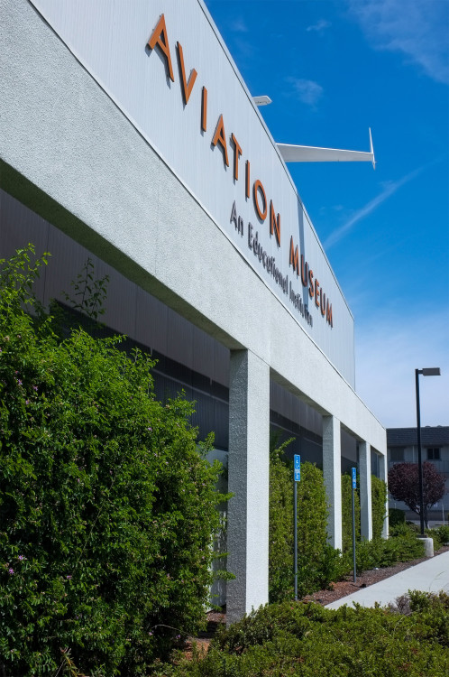
    I’ve driven past Hiller Aviation Museum in San Carlos, CA many times. This afternoon, I finally set foot in the museum and was really impressed with the exhibits.

    Hiller Aviation Museum

    In the lobby, a replica of the Wright Brothers’ plane floats above your head.

    Wright Brothers

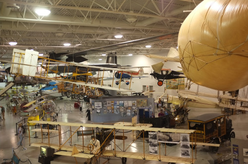
    In the cavernous exhibit hall, you can see an impressive collection of helicopters and airplanes, ranging from the historic to the experimental. The exhibits are well-curated with accompanying explanatory videos.

    hiller-aviation-6358

    Plan on taking about two hours to visit the museum.

  • Mission Peak Regional Preserve

    I climbed up to Mission Peak in the Mission Peak Regional Preserve, which is located at the end of a suburban street in Fremont, California. I arrived shortly before 8 a.m. on a weekend and the parking lot was full. In fact, the entire street leading to the preserve was full.

    Mission Peak

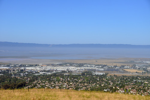
    First off, this was not a hike. From my parking space two blocks away, I had a steady climb up to the entrance of the park. And, as I headed up to the peak, it was an unrelenting uphill march. Not a stretch of flat land where I could relax and catch my breath. I usually get my 10,000 steps in a day so I am not completely out of shape. But, walking up a steady incline is a different beast than walking on level ground, as all the still sore muscles continue to remind me. A bit hazy in the morning, but I did enjoy an aerial view of Fremont.

    mission-peak_0021

    I couldn’t see Mission Peak until the last 20 minutes of the climb. The entire time, I was just focused on the next turn in the trail. Didn’t take long before the people further down the trail looked like little ants.

    Mission Peak

    Eventually, you’ll make one more turn and Mission Peak will be right in front.

    Mission Peak

    Then you wait in line to take a photo with the marker.

    missionpeak_0079

  • D-Day Tours

    Next week, Normandy will celebrate the 70th anniversary of D-Day. I was in Normandy last December and signed up for a tour of Normandy with Christophe Gosselin of Normandy Heritage Tours.

    My adventure started at the Paris Saint Lazare station. I am glad that I arrived early at the station because I needed every single minute to retrieve my tickets from the machine. With my print-out in hand, I walked up to the ticket machine and entered my information, only to be told that my tickets could not be located. That’s when I began my mad search for a staffed ticket office. I walked through the entire station and was redirected to the correct platform and another machine that displayed the same symptoms.

    In addition to the confirmation code, the machine also asked for my name. The reservation listed First-Name Last-Name, so I tried that and it didn’t work. I reversed the order and tried Last-Name First-Name and that didn’t work either. As a last resort, I tried Last-Name only and that worked. The machine promptly printed my tickets and I was off to the platform. The machine should have simply asked for a family name or surname, and I would have be spared from all this angst.

    Upon arriving in Bayeux, we walked to the Hotel Reine Mathilde. The hotel was centrally located within walking distance to the Bayeux Tapestry Museum, Bayeux Cathedral, and nearby shops and restaurants.

    Hotel Reine Mathilde

    The next morning, we met up with Christophe in the hotel lobby. His van comfortably transported us on a private tour of Normandy. If you have time, you may consider a two-day tour. Normandy is such a large area that one-day may not feel enough. It all depends on your level of interest in World War II and historical events.

    Sainte Mere Eglise

    Our first stop was Sainte-Mère-Église, which Google Maps tells me is 55.9 km (39 min) away from Bayeux. On the exterior of the church, you can see a paratrooper with his parachute caught in the tower. Inside the church, we admired the stained glass windows which honored the paratroopers who helped liberate the city.

    Next, we drove along the hedgerows and stopped briefly at the Batteries d’Azeville et de Crisbecq. Then, we proceeded to Utah Beach.

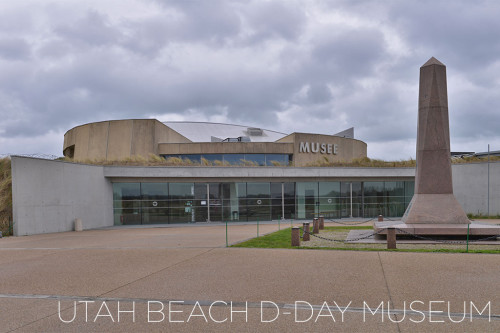
    utah-beach_4582

    The Utah Beach D-Day Museum was closed during our visit. However, there are monuments and artifacts outside that you can see. Even if the museum was open, I’m not sure that we could have spent too much time there since our schedule was quite tight. From there, we drove to the church at Angoville Au Plain, where medics Robert Wright and Kenneth Moore treated soldiers from both sides of the war.

    On D-Day, U.S. Army Rangers had scaled the cliffs to capture Pointe du Hoc. The site itself is quite impressive with massive craters still in place marking the allied bombardment of Pointe du Hoc.

    pointe-du-hoc_4629

    Also, look at the bulk of this casement.

    casement_4630

    Our last destination was the Normandy American Cemetery and Memorial. These men and women gave their lives so that we could be free.

    Normandy American Cemetery

  • Musée des Arts Forains

    On January 1st, I was in Paris. The only problem was that almost all the regular tourist attractions were closed. Fortunately, a few searches on Google along the lines of Paris open new year suggested the Musée des Arts Forains. Despite visiting their website and viewing their numerous photos, I still could not figure out the place. With nothing to lose, our group headed to the Paris Metro for a day of exploration.

    Traveling in a foreign country is a challenge. For those unwilling to pay exorbitant data roaming fees, overseas travel is like a time warp back to the 1980s. I don’t mind traveling on intuition and paper maps, but not everyone is comfortable with those arrangements.

    The Musée des Arts Forains website linked to Les Pavillons de Bercy website, with English directions. But, the bane of all travelers is uncertainty. Why show both the metro stop for Bercy and Cour St Emilion? I really want to memorize just one stop. Cour St Emilion is the closest station.

    From the station, we had no problem finding the Musée des Arts Forains. We still had to walk 5-10 minutes to reach the entrance, but plenty of signs showed us the way.

    Once inside, we had to pay for admission. We then received a ticket each, which was good for one ride. Additional ride tickets are available for purchase.

    One ride we tried was the foot-powered carousel, which consisted of bikes attached together on a circular track. As everyone pedals together, we circled around faster and faster.

    Bike Carousel

    Most rides were in the nature of merry-go-rounds. This attraction looks like a giant swing. I couldn’t tell if it was there just for viewing purposes or the ride was not open at the time.

    Swing

    Besides rides, we were entertained by magicians, musicians, and other performers throughout the day.

    art-forains_5988

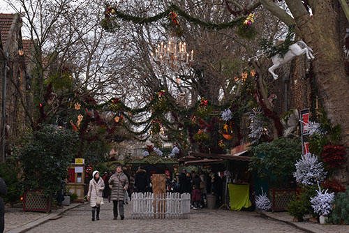
    Outside, the decorations were very much in the holiday spirit, with reindeers and Christmas trees. For food, we purchased tickets at the ticket booth, which we then redeemed at the food booths. I only remember cotton candy, hot dogs (merguez) and drinks, as well as vin chaud (for adults looking to warm up).

    musee-arts-forains_6059

  • Bay Area Discovery Museum

    Located across the Golden Gate Bridge, the Bay Area Discovery Museum offers an engaging experience for young children. During our visit, the museum offered a Framed: Step Into Art exhibit.

    framed_9080

    Basically, the exhibit displays a work of art with the usual description of the artist and the work. However, the exhibit also brought the art to life with an accompanying activity based on the art work.

    art_9086

    The museums exhibits are distributed through a lot of small buildings, with each having a theme. This building had a wave exhibit, which for most kids, meant an opportunity to play with water.

    badm_9099

    We did not explore the interactive playground on account of the summer rain.

    playground_9094

    The mini Golden Gate Bridge is interesting in concept, but there really wasn’t anything to do other than attach plastic panels to it with rivets.

    golden_gate_9095

    During a break in the rain, we did explore this structure which is great for a game of hide-and-seek. You have to explore Lookout Cove to find this since it’s a bit hidden at the far end of the playground.

    hide-and-seek_9115

    I loved the frog instruments. Roll the wooden stick along the frog’s back to make a croaking sound.

    frog-chime_9117

    Finally, we tracked down the source of all the bubbles.

    bubbles_9122

    There is also an art studio where the kids can paint, draw and do other crafts. It’s a great place to take young kids for a few hours.

  • Palo Alto Junior Museum and Zoo

    The Palo Alto Junior Museum and Zoo is a great San Francisco Bay Area destination for children. Located in Palo Alto, the museum offers fun and education exhibits targeted towards its young visitors.

    junior-museum-6536

    The exhibits at the museum do change. The current one is focused on bugs, which showcases various insects.

    bugs-4134

    Outside, you can see the various live animals in their collection. The large pond is home to Roxy, an embden goose, as well as assorted ducks, turtles and rabbits.

    emden-goose-6577

    The bobcats appear more cute than menacing.

    bobcat-4145

    If you are lucky, you’ll see Sequoia the bald eagle or Boeing the red-tailed hawk. They were with their trainers on the day I visited. Not sure where these majestic birds hang out regularly.

    bald-eagle-6598

  • Eshom Campground, Sequoia and Kings Canyon National Park

    While trying to find a campground at Sequoia & Kings Canyon National Park on short notice, I came across Eshom Campground, which had a camp site open for reservations. On Google Maps, the campground appears a short drive from Grant Grove. But, in this case, appearances can be deceiving.

    On the ReserveAmerica website, the location of the camp was given in GPS coordinates, which I had dutifully entered into the NAVIGON iPhone app before departure. I had fully expected to lose cell phone and possibly data connectivity in Sequoia and Kings Canyon National Park, and thought that I had a back-up in NAVIGON.

    So, from Grant Grove, I was presented with two options. ReserveAmerica told me to back track along 180, then take 245 before turning onto Whitaker Forest Drive, which leads to the campground. On the map, this was the roundabout route. On the map, Forest Route 14S75 seems to provide the most direct route. However, (1) it is a dirt road, (2) the path suddenly turns extremely bumpy about half way down, and (3) NAVIGON got confused along the way and kept asking me to make a U-turn along a single path. So, the ReserveAmerica route is the sure thing, while the dirt road option is for the more adventurous, particularly since there is no signage along the way to indicate that you are headed to Eshom Campground.

    I was in camp site #16, which was next to an open field. Although there were tall trees surrounding the camp site, I found enough of a clearing to take some night photos.

  • Sweetwood Group Camp at Half Moon Bay State Beach

    We went camping a few weeks ago at the Sweetwood Group Camp site in Half Moon Bay State Beach. Reserve America rated Sweetwood as primitive, which certain gave me some pause. I wasn’t exactly sure what to expect. As it turned out, we were far from being consigned to the Stone Age at this camp site.

    Sweetwood Group Camp offers a fire pit, picnic benches, running water, and toilets (of the non-flush variety). These amenities are more than adequate for a short weekend outing. The camp site is far from remote, so if you require anything, a number of stores and restaurants are but a short drive away.

    At night, the stars are visible. However, even though I was along the relatively undeveloped coast, there was quite a bit of light pollution. If you want to take photos of the night sky, the best plan would be to check the weather in advance so that you will know if the overhead skies will be clear or cloudy.

    During the day, you will see all types of wildflowers.

    I also loved the pelicans roaming along the coast in search for fish.